HTTP 200 OK
Allow: GET, HEAD, OPTIONS
Content-Type: application/json
Vary: Accept
{
"id": 49,
"files": [],
"main_image": {
"id": 1067,
"uuid": "1b111a6e-b12b-438b-9fdd-c01845673bbc",
"name": "A_AFrank_III_055.132",
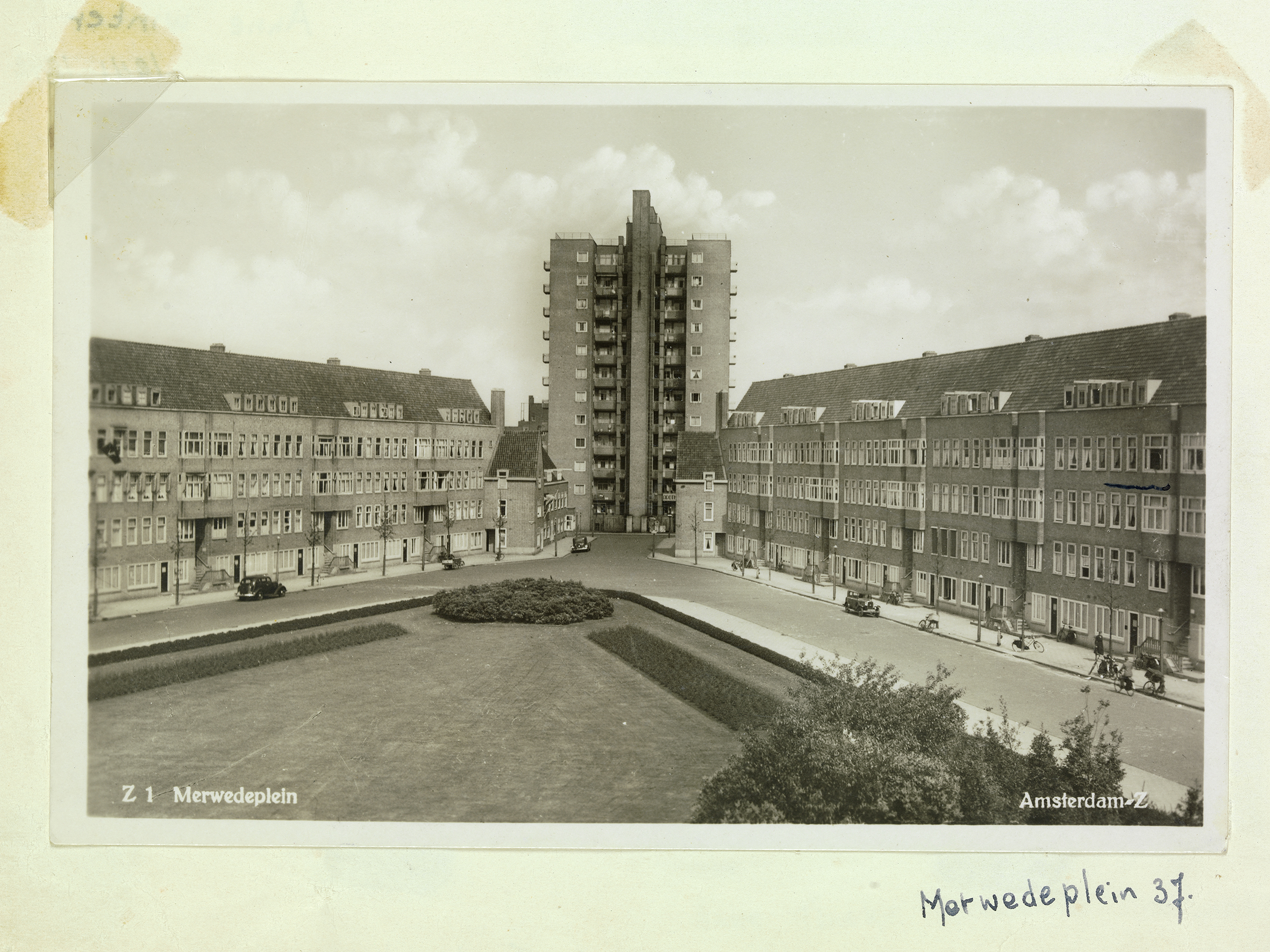
"title": "Ansichtkaart van het Merwedeplein in jaren '30 die Anne in haar fotoalbum plakte. Rechts heeft ze met een streepje aangegeven waar ze woonde.",
"alt": "Vervaardiger onbekend. Fotocollectie Anne Frank Stichting, Amsterdam",
"url": "",
"path": "https://research.annefrank.org/media/A_AFrank_III_055_132verkleind.jpg",
"filetype": "image",
"description": "Foto op p.50 in het album 'Blanco Monster Electro Huishoudboek 1937'. Anne Frank heeft dit album (in ieder geval gedeeltelijk) tijdens de onderduikperiode samengesteld. \r\nAnsichtkaart met opschrift: 'Z. 1 Merwedeplein Amsterdam-Z.' Bijschrift in handschrift Anne: 'Merwedeplein 37.' Rechts bij nr 37 heeft Anne met een streepje haar huis aangegeven.",
"author": "De collectie kan worden ingezet voor publiek",
"copyright": "Publiek domein"
},
"latitude": "52.345929",
"longitude": "4.902652",
"events": [],
"subjects": [
{
"id": 396124506,
"image": null,
"url": "https://research.annefrank.org/en/onderwerpen/233f34c4-f312-4cac-b08e-71819db78627/",
"published": true,
"uuid": "233f34c4-f312-4cac-b08e-71819db78627",
"name": "Rivierenbuurt",
"name_nl": "Rivierenbuurt",
"name_en": "Rivierenbuurt",
"description": "<p>The <em>Rivierenbuurt</em> is a neighbourhood located in the east of Amsterdam's Zuid district, bounded by the Amstel River to the east, the Boerenwetering to the west, the Amstel Canal to the north, and the Zuidelijke Wandelweg to the south. It is part of <em>Plan Zuid</em>, an urban development plan for Amsterdam South designed by architect H.P Berlage in the early <strong>20th</strong> century.<sup data-footnote-id=\"paafj\"><a href=\"#footnote-1\" id=\"footnote-marker-1-1\" rel=\"footnote\">[1]</a></sup></p>\r\n\r\n<p><em>Plan Zuid</em> consisted of three parts: the <em>Apollobuurt</em> and <em>Stadionbuurt</em>, aimed at the well-to-do, middle and working classes, and the <em>Rivierenbuurt</em>, aimed at the middle classes. A large part of the <em>Nieuwe Pijp</em> neighbourhood was also part of <em>Plan Zuid</em>. The urban plan envisaged that three main streets (the <em>Amstellanen</em>) would cut through the neighbourhood in a Y-shape, converging on Daniël Willinkplein, named after the Dutch writer Daniël Willink (1676-1722).<sup data-footnote-id=\"snfsd\"><a href=\"#footnote-2\" id=\"footnote-marker-2-1\" rel=\"footnote\">[2]</a></sup> These were Amstellaan (after the war this became Stalinlaan and in <strong>1956</strong>, after the Russian invasion of Hungary, changed to Vrijheidslaan), Noorder Amstellaan (now Churchilllaan) and Zuider Amstellaan (now Rooseveltlaan).<sup data-footnote-id=\"hk7av\"><a href=\"#footnote-3\" id=\"footnote-marker-3-1\" rel=\"footnote\">[3]</a></sup> The other street names in the neighbourhood were named after Dutch rivers.<sup data-footnote-id=\"xk4k5\"><a href=\"#footnote-4\" id=\"footnote-marker-4-1\" rel=\"footnote\">[4]</a></sup></p>\r\n\r\n<p>The houses in the <em>Rivierenbuurt</em> exerted great attraction on middle-class Jewish Amsterdammers from the early <strong>1930s</strong>. In terms of size and amenities, they contrasted particularly favourably with the small, poor houses in the overcrowded Jewish quarter around Waterlooplein. Nevertheless, there was a lot of vacancy in the <strong>1930s</strong>, and as a result, many German Jews who fled to the Netherlands from Nazi Germany also settled here, including the Frank and Van Pels families and some of their friends and acquaintances. The immigrants felt at home in this neighbourhood with its many fellow Jews. Eventually, by <strong>1940</strong>, around 40 per cent of the Jews living in Amsterdam lived in this part of the city.<sup data-footnote-id=\"xk4k5\"><a href=\"#footnote-4\" id=\"footnote-marker-4-2\" rel=\"footnote\">[4]</a></sup></p>\r\n\r\n<section class=\"footnotes\">\r\n<header>\r\n<h2>Footnotes</h2>\r\n</header>\r\n\r\n<ol>\r\n\t<li data-footnote-id=\"paafj\" id=\"footnote-1\"><sup><a href=\"#footnote-marker-1-1\">^</a> </sup><cite>Zie <a href=\"https://nl.wikipedia.org/wiki/Plan_Zuid\" target=\"_blank\">https://nl.wikipedia.org/wiki/Plan_Zuid</a> (geraadpleegd 19 november 2022).</cite></li>\r\n\t<li data-footnote-id=\"snfsd\" id=\"footnote-2\"><sup><a href=\"#footnote-marker-2-1\">^</a> </sup><cite>Het Daniël Willinkplein werd kort na de oorlog, naar aanleiding van de overwinning van de Geallieerden, omgedoopt tot Victorieplein; zie <a href=\"https://nl.wikipedia.org/wiki/Victorieplein_(Amsterdam)\" target=\"_blank\">https://nl.wikipedia.org/wiki/Victorieplein_(Amsterdam)</a> (geraadpleegd 19 november 2022).</cite></li>\r\n\t<li data-footnote-id=\"hk7av\" id=\"footnote-3\"><sup><a href=\"#footnote-marker-3-1\">^</a> </sup><cite>Zie <a href=\"https://nl.wikipedia.org/wiki/Amstellanen\" target=\"_blank\">https://nl.wikipedia.org/wiki/Amstellanen</a> (geraadpleegd 19 ovember 2022).</cite></li>\r\n\t<li data-footnote-id=\"xk4k5\" id=\"footnote-4\"><sup><a href=\"#footnote-marker-4-1\">a</a>, <a href=\"#footnote-marker-4-2\">b</a> </sup><cite>Zie <a href=\"https://nl.wikipedia.org/wiki/Rivierenbuurt_(Amsterdam)\" target=\"_blank\">https://nl.wikipedia.org/wiki/Rivierenbuurt_(Amsterdam)</a> (geraadpleegd 19 november 2022).</cite></li>\r\n</ol>\r\n</section>",
"description_nl": "<p>De <em>Rivierenbuurt</em> is een in het oosten van het Amsterdamse stadsdeel Zuid gelegen buurt, die wordt begrensd door de Amstelrivier in het oosten, de Boerenwetering in het westen, het Amstelkanaal in het noorden, en de Zuidelijke Wandelweg in het zuiden. Het maakt deel uit van <em>Plan Zuid</em>, een stedenbouwkundig plan voor Amsterdam-Zuid, dat in het begin van de <strong>20e eeuw</strong> werd ontworpen door de architect H.P Berlage.<sup data-footnote-id=\"paafj\"><a href=\"#footnote-1\" id=\"footnote-marker-1-1\" rel=\"footnote\">[1]</a></sup></p>\r\n\r\n<p><em>Plan Zuid</em> bestond uit drie delen: de <em>Apollobuurt</em> en de <em>Stadionbuurt</em>, gericht op welgestelden, middenklasse en arbeidersklasse, en de <em>Rivierenbuurt</em>, gericht op de middenklasse. Ook een groot deel van de buurt <em>Nieuwe Pijp</em> behoort tot het <em>Plan Zuid</em>. In het stedenbouwkundig plan was bedacht dat drie hoofdstraten (de Amstellanen) de buurt in een Y-vorm zouden doorsnijden, en samen zouden komen op het Daniël Willinkplein, een vernoeming naar de Nederlandse schrijver Daniël Willink (1676-1722).<sup data-footnote-id=\"snfsd\"><a href=\"#footnote-2\" id=\"footnote-marker-2-1\" rel=\"footnote\">[2]</a></sup> Dit waren de Amstellaan (na de oorlog werd dit de Stalinlaan en in <strong>1956</strong>, na de Russische inval in Hongarije, gewijzigd in Vrijheidslaan), Noorder Amstellaan (nu Churchill-laan) en Zuider Amstellaan (nu Rooseveltlaan).<sup data-footnote-id=\"hk7av\"><a href=\"#footnote-3\" id=\"footnote-marker-3-1\" rel=\"footnote\">[3]</a></sup> De overige straatnamen in de buurt werden vernoemd naar Nederlandse rivieren.<sup data-footnote-id=\"xk4k5\"><a href=\"#footnote-4\" id=\"footnote-marker-4-1\" rel=\"footnote\">[4]</a></sup></p>\r\n\r\n<p>De woningen in de <em>Rivierenbuurt</em> oefenden vanaf het begin van de <strong>jaren dertig</strong> grote aantrekkingskracht uit op Joodse Amsterdammers uit de middenklasse. Qua grootte en voorzieningen staken zij bijzonder gunstig af tegen de kleine, slechte woningen in de overbevolkte Jodenbuurt rond het Waterlooplein. Toch was er in de <strong>jaren dertig</strong> veel leegstand, en daardoor streken ook veel Duitse Joden die vanuit nazi-Duitsland naar Nederland vluchtten, hier neer, waaronder ook de families Frank en Van Pels en een aantal van hun vrienden en kennissen. De immigranten voelden zich thuis in deze buurt met de vele geloofsgenoten. Uiteindelijk woonde in <strong>1940</strong> zo'n 40% van de in Amsterdam wonende Joden in dit deel van de stad.<sup data-footnote-id=\"xk4k5\"><a href=\"#footnote-4\" id=\"footnote-marker-4-2\" rel=\"footnote\">[4]</a></sup></p>\r\n\r\n<section class=\"footnotes\">\r\n<header>\r\n<h2>Footnotes</h2>\r\n</header>\r\n\r\n<ol>\r\n\t<li data-footnote-id=\"paafj\" id=\"footnote-1\"><sup><a href=\"#footnote-marker-1-1\">^</a> </sup><cite>Zie <a href=\"https://nl.wikipedia.org/wiki/Plan_Zuid\" target=\"_blank\">https://nl.wikipedia.org/wiki/Plan_Zuid</a> (geraadpleegd 19 november 2022).</cite></li>\r\n\t<li data-footnote-id=\"snfsd\" id=\"footnote-2\"><sup><a href=\"#footnote-marker-2-1\">^</a> </sup><cite>Het Daniël Willinkplein werd kort na de oorlog, naar aanleiding van de overwinning van de Geallieerden, omgedoopt tot Victorieplein; zie <a href=\"https://nl.wikipedia.org/wiki/Victorieplein_(Amsterdam)\" target=\"_blank\">https://nl.wikipedia.org/wiki/Victorieplein_(Amsterdam)</a> (geraadpleegd 19 november 2022).</cite></li>\r\n\t<li data-footnote-id=\"hk7av\" id=\"footnote-3\"><sup><a href=\"#footnote-marker-3-1\">^</a> </sup><cite>Zie <a href=\"https://nl.wikipedia.org/wiki/Amstellanen\" target=\"_blank\">https://nl.wikipedia.org/wiki/Amstellanen</a> (geraadpleegd 19 ovember 2022).</cite></li>\r\n\t<li data-footnote-id=\"xk4k5\" id=\"footnote-4\"><sup><a href=\"#footnote-marker-4-1\">a</a>, <a href=\"#footnote-marker-4-2\">b</a> </sup><cite>Zie <a href=\"https://nl.wikipedia.org/wiki/Rivierenbuurt_(Amsterdam)\" target=\"_blank\">https://nl.wikipedia.org/wiki/Rivierenbuurt_(Amsterdam)</a> (geraadpleegd 19 november 2022).</cite></li>\r\n</ol>\r\n</section>",
"description_en": "<p>The <em>Rivierenbuurt</em> is a neighbourhood located in the east of Amsterdam's Zuid district, bounded by the Amstel River to the east, the Boerenwetering to the west, the Amstel Canal to the north, and the Zuidelijke Wandelweg to the south. It is part of <em>Plan Zuid</em>, an urban development plan for Amsterdam South designed by architect H.P Berlage in the early <strong>20th</strong> century.<sup data-footnote-id=\"paafj\"><a href=\"#footnote-1\" id=\"footnote-marker-1-1\" rel=\"footnote\">[1]</a></sup></p>\r\n\r\n<p><em>Plan Zuid</em> consisted of three parts: the <em>Apollobuurt</em> and <em>Stadionbuurt</em>, aimed at the well-to-do, middle and working classes, and the <em>Rivierenbuurt</em>, aimed at the middle classes. A large part of the <em>Nieuwe Pijp</em> neighbourhood was also part of <em>Plan Zuid</em>. The urban plan envisaged that three main streets (the <em>Amstellanen</em>) would cut through the neighbourhood in a Y-shape, converging on Daniël Willinkplein, named after the Dutch writer Daniël Willink (1676-1722).<sup data-footnote-id=\"snfsd\"><a href=\"#footnote-2\" id=\"footnote-marker-2-1\" rel=\"footnote\">[2]</a></sup> These were Amstellaan (after the war this became Stalinlaan and in <strong>1956</strong>, after the Russian invasion of Hungary, changed to Vrijheidslaan), Noorder Amstellaan (now Churchilllaan) and Zuider Amstellaan (now Rooseveltlaan).<sup data-footnote-id=\"hk7av\"><a href=\"#footnote-3\" id=\"footnote-marker-3-1\" rel=\"footnote\">[3]</a></sup> The other street names in the neighbourhood were named after Dutch rivers.<sup data-footnote-id=\"xk4k5\"><a href=\"#footnote-4\" id=\"footnote-marker-4-1\" rel=\"footnote\">[4]</a></sup></p>\r\n\r\n<p>The houses in the <em>Rivierenbuurt</em> exerted great attraction on middle-class Jewish Amsterdammers from the early <strong>1930s</strong>. In terms of size and amenities, they contrasted particularly favourably with the small, poor houses in the overcrowded Jewish quarter around Waterlooplein. Nevertheless, there was a lot of vacancy in the <strong>1930s</strong>, and as a result, many German Jews who fled to the Netherlands from Nazi Germany also settled here, including the Frank and Van Pels families and some of their friends and acquaintances. The immigrants felt at home in this neighbourhood with its many fellow Jews. Eventually, by <strong>1940</strong>, around 40 per cent of the Jews living in Amsterdam lived in this part of the city.<sup data-footnote-id=\"xk4k5\"><a href=\"#footnote-4\" id=\"footnote-marker-4-2\" rel=\"footnote\">[4]</a></sup></p>\r\n\r\n<section class=\"footnotes\">\r\n<header>\r\n<h2>Footnotes</h2>\r\n</header>\r\n\r\n<ol>\r\n\t<li data-footnote-id=\"paafj\" id=\"footnote-1\"><sup><a href=\"#footnote-marker-1-1\">^</a> </sup><cite>Zie <a href=\"https://nl.wikipedia.org/wiki/Plan_Zuid\" target=\"_blank\">https://nl.wikipedia.org/wiki/Plan_Zuid</a> (geraadpleegd 19 november 2022).</cite></li>\r\n\t<li data-footnote-id=\"snfsd\" id=\"footnote-2\"><sup><a href=\"#footnote-marker-2-1\">^</a> </sup><cite>Het Daniël Willinkplein werd kort na de oorlog, naar aanleiding van de overwinning van de Geallieerden, omgedoopt tot Victorieplein; zie <a href=\"https://nl.wikipedia.org/wiki/Victorieplein_(Amsterdam)\" target=\"_blank\">https://nl.wikipedia.org/wiki/Victorieplein_(Amsterdam)</a> (geraadpleegd 19 november 2022).</cite></li>\r\n\t<li data-footnote-id=\"hk7av\" id=\"footnote-3\"><sup><a href=\"#footnote-marker-3-1\">^</a> </sup><cite>Zie <a href=\"https://nl.wikipedia.org/wiki/Amstellanen\" target=\"_blank\">https://nl.wikipedia.org/wiki/Amstellanen</a> (geraadpleegd 19 ovember 2022).</cite></li>\r\n\t<li data-footnote-id=\"xk4k5\" id=\"footnote-4\"><sup><a href=\"#footnote-marker-4-1\">a</a>, <a href=\"#footnote-marker-4-2\">b</a> </sup><cite>Zie <a href=\"https://nl.wikipedia.org/wiki/Rivierenbuurt_(Amsterdam)\" target=\"_blank\">https://nl.wikipedia.org/wiki/Rivierenbuurt_(Amsterdam)</a> (geraadpleegd 19 november 2022).</cite></li>\r\n</ol>\r\n</section>",
"summary": "The Rivierenbuurt is a neighbourhood located in the east of Amsterdam's Zuid district where many Jewish residents settled from the 1930s onwards.",
"summary_nl": "De Rivierenbuurt is een in het oosten van het Amsterdamse stadsdeel Zuid gelegen buurt waar zich vanaf de jaren dertig veel Joodse inwoners hebben gevestigd.",
"summary_en": "The Rivierenbuurt is a neighbourhood located in the east of Amsterdam's Zuid district where many Jewish residents settled from the 1930s onwards.",
"same_as": null,
"parent": 396124553,
"files": []
}
],
"related_locations": [
"https://research.annefrank.org/en/api/locations/04bc398b-9132-421d-be07-26d89aecf727?format=api",
"https://research.annefrank.org/en/api/locations/5e6e4c0b-e255-4b81-9abc-a8b22fd9d87c?format=api",
"https://research.annefrank.org/en/api/locations/4caabcc8-204b-438d-915c-1e6ea54630bb?format=api",
"https://research.annefrank.org/en/api/locations/f139a0d3-6359-4ad4-946d-b2ee153e7b99?format=api",
"https://research.annefrank.org/en/api/locations/889ae572-cc0a-4847-b3c9-3bf177af8ecc?format=api",
"https://research.annefrank.org/en/api/locations/64af952c-9403-4db9-b2cb-5ba310b33332?format=api",
"https://research.annefrank.org/en/api/locations/2ce70ffc-474f-4743-a9a8-dd4ed4e59c77?format=api",
"https://research.annefrank.org/en/api/locations/88db758b-1dac-4579-86c6-33cc2bdc5273?format=api",
"https://research.annefrank.org/en/api/locations/e48c8d0c-8825-4c34-bd22-8c2a28adb089?format=api",
"https://research.annefrank.org/en/api/locations/9c7b897a-5803-4d3a-a810-d05792a6ff5f?format=api",
"https://research.annefrank.org/en/api/locations/838a9a83-171f-44ec-8a97-0024ebf8b5b6?format=api",
"https://research.annefrank.org/en/api/locations/6b0dbaa0-4815-4f3e-ab1c-e0ee6196188e?format=api",
"https://research.annefrank.org/en/api/locations/36a662f9-f828-44ad-9609-bd8901c723f4?format=api",
"https://research.annefrank.org/en/api/locations/663c8bc9-dc5c-4dd1-bced-88ce12738280?format=api",
"https://research.annefrank.org/en/api/locations/c4260f04-7551-463d-89f5-a7ce48eeecd3?format=api",
"https://research.annefrank.org/en/api/locations/903ba158-f1e0-4d0f-b613-eae91df2893e?format=api",
"https://research.annefrank.org/en/api/locations/b6bed785-6178-42d2-9f90-a90e7730c21e?format=api",
"https://research.annefrank.org/en/api/locations/5c9289eb-d4f6-46b8-afe7-5c15df9164c3?format=api",
"https://research.annefrank.org/en/api/locations/aab06445-fe04-4578-9fba-19e679b65d6d?format=api",
"https://research.annefrank.org/en/api/locations/6a58ce7e-02e2-4517-85ce-5b03eb20b753?format=api",
"https://research.annefrank.org/en/api/locations/b7c73757-981c-409e-95cc-cc8eab873a93?format=api",
"https://research.annefrank.org/en/api/locations/da7429b4-b23f-4947-b6d8-e5e6c0f143c3?format=api",
"https://research.annefrank.org/en/api/locations/6660d32e-d2b0-468d-b7e7-01ceefc4376d?format=api",
"https://research.annefrank.org/en/api/locations/05693431-6b99-47b4-8e47-59ab3e95a889?format=api",
"https://research.annefrank.org/en/api/locations/a423c2ce-aac1-4ff6-86b1-f5233e4b77ff?format=api",
"https://research.annefrank.org/en/api/locations/0ccf3db9-1774-4848-ad11-627e3fc64cea?format=api",
"https://research.annefrank.org/en/api/locations/aa7d60c3-6d94-4f52-a729-96440eeb4d5f?format=api"
],
"url": "https://research.annefrank.org/en/locaties/dd7e96a8-2902-4144-99a7-2aef084ed61d/",
"published": true,
"name": "Skyscraper",
"name_nl": "Wolkenkrabber",
"name_en": "Skyscraper",
"uuid": "dd7e96a8-2902-4144-99a7-2aef084ed61d",
"content": "<p>The Skyscraper, or the 12-storey house, is a striking building in Amsterdam's Plan Zuid due to its height. It is located at Victorieplein, which was named Daniël Willinkplein before the war.<sup data-footnote-id=\"9hg7o\"><a href=\"#footnote-1\" id=\"footnote-marker-1-1\" rel=\"footnote\">[1]</a></sup> Upon completion, the <em>Telegraaf</em> called the building the second skyscraper in Amsterdam. The first one was the Candida building at 120 Nieuwezijds Voorburgwal, where Otto Frank established his Opekta firm in <strong>1933</strong>. The materials used were made as much as possible by Dutch industry<sup data-footnote-id=\"s4ns5\"><a href=\"#footnote-2\" id=\"footnote-marker-2-1\" rel=\"footnote\">[2]</a></sup></p>\r\n\r\n<section class=\"footnotes\">\r\n<header>\r\n<h2>Footnotes</h2>\r\n</header>\r\n\r\n<ol>\r\n\t<li data-footnote-id=\"9hg7o\" id=\"footnote-1\"><sup><a href=\"#footnote-marker-1-1\">^</a> </sup><cite>See: Geheugen van Plan Zuid: <a href=\"https://www.geheugenvanplanzuid.nl/index.php/architectuur/151-wolkenkrabber\" target=\"_blank\">Hoogbouw: Wolkenkrabber</a>.</cite></li>\r\n\t<li data-footnote-id=\"s4ns5\" id=\"footnote-2\"><sup><a href=\"#footnote-marker-2-1\">^</a> </sup><cite>"Onze tweede Wolkenkrabber", <em>De Telegraaf</em>, 11 september 1931.</cite></li>\r\n</ol>\r\n</section>",
"content_nl": "<p>De Wolkenkrabber, of het 12-verdiepingenhuis, is door zijn hoogte een opvallend gebouw in Plan-Zuid. Het staat aan het Victorieplein dat in Annes tijd Daniël Willinkplein heette.<sup data-footnote-id=\"pavfz\"><a href=\"#footnote-1\" id=\"footnote-marker-1-1\" rel=\"footnote\">[1]</a></sup> <em>De Telegraaf</em> noemde het gebouw bij de oplevering de tweede wolkenkrabber van Amsterdam. De eerste was dan gebouw Candida aan de Nieuwezijds Voorburgwal 120, waar Otto Frank in <strong>1933</strong> zijn Opekta vestigde. De gebruikte materialen waren zoveel mogelijk door de Nederlandse industrie gemaakt.<sup data-footnote-id=\"s4ns5\"><a href=\"#footnote-2\" id=\"footnote-marker-2-1\" rel=\"footnote\">[2]</a></sup></p>\r\n\r\n<section class=\"footnotes\">\r\n<header>\r\n<h2>Footnotes</h2>\r\n</header>\r\n\r\n<ol>\r\n\t<li data-footnote-id=\"pavfz\" id=\"footnote-1\"><sup><a href=\"#footnote-marker-1-1\">^</a> </sup><cite>Zie: Geheugen van Plan Zuid: <a href=\"https://www.geheugenvanplanzuid.nl/index.php/architectuur/151-wolkenkrabber\" target=\"_blank\">Hoogbouw: Wolkenkrabber</a>.</cite></li>\r\n\t<li data-footnote-id=\"s4ns5\" id=\"footnote-2\"><sup><a href=\"#footnote-marker-2-1\">^</a> </sup><cite>"Onze tweede Wolkenkrabber", <em>De Telegraaf</em>, 11 september 1931.</cite></li>\r\n</ol>\r\n</section>",
"content_en": "<p>The Skyscraper, or the 12-storey house, is a striking building in Amsterdam's Plan Zuid due to its height. It is located at Victorieplein, which was named Daniël Willinkplein before the war.<sup data-footnote-id=\"9hg7o\"><a href=\"#footnote-1\" id=\"footnote-marker-1-1\" rel=\"footnote\">[1]</a></sup> Upon completion, the <em>Telegraaf</em> called the building the second skyscraper in Amsterdam. The first one was the Candida building at 120 Nieuwezijds Voorburgwal, where Otto Frank established his Opekta firm in <strong>1933</strong>. The materials used were made as much as possible by Dutch industry<sup data-footnote-id=\"s4ns5\"><a href=\"#footnote-2\" id=\"footnote-marker-2-1\" rel=\"footnote\">[2]</a></sup></p>\r\n\r\n<section class=\"footnotes\">\r\n<header>\r\n<h2>Footnotes</h2>\r\n</header>\r\n\r\n<ol>\r\n\t<li data-footnote-id=\"9hg7o\" id=\"footnote-1\"><sup><a href=\"#footnote-marker-1-1\">^</a> </sup><cite>See: Geheugen van Plan Zuid: <a href=\"https://www.geheugenvanplanzuid.nl/index.php/architectuur/151-wolkenkrabber\" target=\"_blank\">Hoogbouw: Wolkenkrabber</a>.</cite></li>\r\n\t<li data-footnote-id=\"s4ns5\" id=\"footnote-2\"><sup><a href=\"#footnote-marker-2-1\">^</a> </sup><cite>"Onze tweede Wolkenkrabber", <em>De Telegraaf</em>, 11 september 1931.</cite></li>\r\n</ol>\r\n</section>",
"position": "SRID=4326;POINT (4.902652 52.345929)",
"summary": "The Skyscraper, or the 12-storey house, is a striking building in the Rivierenbuurt in Amsterdam South due to its height. It is located in the center of Victorieplein.",
"summary_nl": "De Wolkenkrabber, of het 12-verdiepingenhuis, is door zijn hoogte een opvallend gebouw in de Rivierenbuurt in Amsterdam-Zuid. Het staat in het centrum van het Victorieplein.",
"summary_en": "The Skyscraper, or the 12-storey house, is a striking building in the Rivierenbuurt in Amsterdam South due to its height. It is located in the center of Victorieplein.",
"same_as": null,
"street": "Victorieplein 45-47",
"zipcode": "1078 PD",
"city": "Amsterdam",
"state": "",
"land": "Nederland",
"location_events": []
}