HTTP 200 OK
Allow: GET, HEAD, OPTIONS
Content-Type: application/json
Vary: Accept
{
"id": 63,
"files": [],
"main_image": {
"id": 1116,
"uuid": "311e0d50-829a-4d25-833c-c07dd1518fc6",
"name": "WKSAA00093000526",
"title": "Woningkaart Gaaspstraat 12, later 25.",
"alt": "Stadsarchief Amsterdam. Dienst Bevolkingsregister, woningkaarten.",
"url": "",
"path": "https://research.annefrank.org/media/WKSAA00093000526.jpg",
"filetype": "image",
"description": "",
"author": "Collectie kan worden ingezet voor publiek.",
"copyright": "Publiek domein."
},
"latitude": "52.344589",
"longitude": "4.90837",
"events": [
{
"id": 294,
"main_image": null,
"url": "https://research.annefrank.org/en/gebeurtenissen/6ac4c1af-cf5f-4bf0-8201-a87ff7d39a4f/",
"subjects": [
"https://research.annefrank.org/en/api/subjects/d7ba8d2c-3824-4286-96da-1af0f02ba645?format=api",
"https://research.annefrank.org/en/api/subjects/e668255b-67ef-4ad1-8f2e-fdc1084aff25?format=api"
],
"persons": [
"https://research.annefrank.org/en/api/persons/960fd1b1-4b84-4e4b-9eac-145c17dbf2b2?format=api",
"https://research.annefrank.org/en/api/persons/91ba36dd-a23f-47d8-9821-f5242644ad37?format=api",
"https://research.annefrank.org/en/api/persons/f28309bf-8611-4332-aef1-3114364250f9?format=api"
],
"location": "https://research.annefrank.org/en/api/locations/6a58ce7e-02e2-4517-85ce-5b03eb20b753?format=api",
"published": true,
"uuid": "6ac4c1af-cf5f-4bf0-8201-a87ff7d39a4f",
"name": "Miep Santrouschitz lives in the Gaaspstraat, Amsterdam",
"name_nl": "Miep Santrouschitz woont in de Gaaspstraat, Amsterdam",
"name_en": "Miep Santrouschitz lives in the Gaaspstraat, Amsterdam",
"content": "",
"content_nl": "",
"content_en": "",
"date": null,
"date_start": "1928-04-05",
"date_end": "1941-07-16",
"summary": "Miep Santrouschitz lived with her foster family in Amsterdam from 1924 to 16 July 1941. From 1928 in the Gaaspstraat.",
"summary_nl": "Miep Santrouschitz woonde van 1924 tot 16 juli 1941 met haar pleegfamilie in Amsterdam. Vanaf 1928 in de Gaaspstraat.",
"summary_en": "Miep Santrouschitz lived with her foster family in Amsterdam from 1924 to 16 July 1941. From 1928 in the Gaaspstraat.",
"same_as": null,
"files": []
}
],
"subjects": [
{
"id": 396124506,
"image": null,
"url": "https://research.annefrank.org/en/onderwerpen/233f34c4-f312-4cac-b08e-71819db78627/",
"published": true,
"uuid": "233f34c4-f312-4cac-b08e-71819db78627",
"name": "Rivierenbuurt",
"name_nl": "Rivierenbuurt",
"name_en": "Rivierenbuurt",
"description": "<p>The <em>Rivierenbuurt</em> is a neighbourhood located in the east of Amsterdam's Zuid district, bounded by the Amstel River to the east, the Boerenwetering to the west, the Amstel Canal to the north, and the Zuidelijke Wandelweg to the south. It is part of <em>Plan Zuid</em>, an urban development plan for Amsterdam South designed by architect H.P Berlage in the early <strong>20th</strong> century.<sup data-footnote-id=\"paafj\"><a href=\"#footnote-1\" id=\"footnote-marker-1-1\" rel=\"footnote\">[1]</a></sup></p>\r\n\r\n<p><em>Plan Zuid</em> consisted of three parts: the <em>Apollobuurt</em> and <em>Stadionbuurt</em>, aimed at the well-to-do, middle and working classes, and the <em>Rivierenbuurt</em>, aimed at the middle classes. A large part of the <em>Nieuwe Pijp</em> neighbourhood was also part of <em>Plan Zuid</em>. The urban plan envisaged that three main streets (the <em>Amstellanen</em>) would cut through the neighbourhood in a Y-shape, converging on Daniël Willinkplein, named after the Dutch writer Daniël Willink (1676-1722).<sup data-footnote-id=\"snfsd\"><a href=\"#footnote-2\" id=\"footnote-marker-2-1\" rel=\"footnote\">[2]</a></sup> These were Amstellaan (after the war this became Stalinlaan and in <strong>1956</strong>, after the Russian invasion of Hungary, changed to Vrijheidslaan), Noorder Amstellaan (now Churchilllaan) and Zuider Amstellaan (now Rooseveltlaan).<sup data-footnote-id=\"hk7av\"><a href=\"#footnote-3\" id=\"footnote-marker-3-1\" rel=\"footnote\">[3]</a></sup> The other street names in the neighbourhood were named after Dutch rivers.<sup data-footnote-id=\"xk4k5\"><a href=\"#footnote-4\" id=\"footnote-marker-4-1\" rel=\"footnote\">[4]</a></sup></p>\r\n\r\n<p>The houses in the <em>Rivierenbuurt</em> exerted great attraction on middle-class Jewish Amsterdammers from the early <strong>1930s</strong>. In terms of size and amenities, they contrasted particularly favourably with the small, poor houses in the overcrowded Jewish quarter around Waterlooplein. Nevertheless, there was a lot of vacancy in the <strong>1930s</strong>, and as a result, many German Jews who fled to the Netherlands from Nazi Germany also settled here, including the Frank and Van Pels families and some of their friends and acquaintances. The immigrants felt at home in this neighbourhood with its many fellow Jews. Eventually, by <strong>1940</strong>, around 40 per cent of the Jews living in Amsterdam lived in this part of the city.<sup data-footnote-id=\"xk4k5\"><a href=\"#footnote-4\" id=\"footnote-marker-4-2\" rel=\"footnote\">[4]</a></sup></p>\r\n\r\n<section class=\"footnotes\">\r\n<header>\r\n<h2>Footnotes</h2>\r\n</header>\r\n\r\n<ol>\r\n\t<li data-footnote-id=\"paafj\" id=\"footnote-1\"><sup><a href=\"#footnote-marker-1-1\">^</a> </sup><cite>Zie <a href=\"https://nl.wikipedia.org/wiki/Plan_Zuid\" target=\"_blank\">https://nl.wikipedia.org/wiki/Plan_Zuid</a> (geraadpleegd 19 november 2022).</cite></li>\r\n\t<li data-footnote-id=\"snfsd\" id=\"footnote-2\"><sup><a href=\"#footnote-marker-2-1\">^</a> </sup><cite>Het Daniël Willinkplein werd kort na de oorlog, naar aanleiding van de overwinning van de Geallieerden, omgedoopt tot Victorieplein; zie <a href=\"https://nl.wikipedia.org/wiki/Victorieplein_(Amsterdam)\" target=\"_blank\">https://nl.wikipedia.org/wiki/Victorieplein_(Amsterdam)</a> (geraadpleegd 19 november 2022).</cite></li>\r\n\t<li data-footnote-id=\"hk7av\" id=\"footnote-3\"><sup><a href=\"#footnote-marker-3-1\">^</a> </sup><cite>Zie <a href=\"https://nl.wikipedia.org/wiki/Amstellanen\" target=\"_blank\">https://nl.wikipedia.org/wiki/Amstellanen</a> (geraadpleegd 19 ovember 2022).</cite></li>\r\n\t<li data-footnote-id=\"xk4k5\" id=\"footnote-4\"><sup><a href=\"#footnote-marker-4-1\">a</a>, <a href=\"#footnote-marker-4-2\">b</a> </sup><cite>Zie <a href=\"https://nl.wikipedia.org/wiki/Rivierenbuurt_(Amsterdam)\" target=\"_blank\">https://nl.wikipedia.org/wiki/Rivierenbuurt_(Amsterdam)</a> (geraadpleegd 19 november 2022).</cite></li>\r\n</ol>\r\n</section>",
"description_nl": "<p>De <em>Rivierenbuurt</em> is een in het oosten van het Amsterdamse stadsdeel Zuid gelegen buurt, die wordt begrensd door de Amstelrivier in het oosten, de Boerenwetering in het westen, het Amstelkanaal in het noorden, en de Zuidelijke Wandelweg in het zuiden. Het maakt deel uit van <em>Plan Zuid</em>, een stedenbouwkundig plan voor Amsterdam-Zuid, dat in het begin van de <strong>20e eeuw</strong> werd ontworpen door de architect H.P Berlage.<sup data-footnote-id=\"paafj\"><a href=\"#footnote-1\" id=\"footnote-marker-1-1\" rel=\"footnote\">[1]</a></sup></p>\r\n\r\n<p><em>Plan Zuid</em> bestond uit drie delen: de <em>Apollobuurt</em> en de <em>Stadionbuurt</em>, gericht op welgestelden, middenklasse en arbeidersklasse, en de <em>Rivierenbuurt</em>, gericht op de middenklasse. Ook een groot deel van de buurt <em>Nieuwe Pijp</em> behoort tot het <em>Plan Zuid</em>. In het stedenbouwkundig plan was bedacht dat drie hoofdstraten (de Amstellanen) de buurt in een Y-vorm zouden doorsnijden, en samen zouden komen op het Daniël Willinkplein, een vernoeming naar de Nederlandse schrijver Daniël Willink (1676-1722).<sup data-footnote-id=\"snfsd\"><a href=\"#footnote-2\" id=\"footnote-marker-2-1\" rel=\"footnote\">[2]</a></sup> Dit waren de Amstellaan (na de oorlog werd dit de Stalinlaan en in <strong>1956</strong>, na de Russische inval in Hongarije, gewijzigd in Vrijheidslaan), Noorder Amstellaan (nu Churchill-laan) en Zuider Amstellaan (nu Rooseveltlaan).<sup data-footnote-id=\"hk7av\"><a href=\"#footnote-3\" id=\"footnote-marker-3-1\" rel=\"footnote\">[3]</a></sup> De overige straatnamen in de buurt werden vernoemd naar Nederlandse rivieren.<sup data-footnote-id=\"xk4k5\"><a href=\"#footnote-4\" id=\"footnote-marker-4-1\" rel=\"footnote\">[4]</a></sup></p>\r\n\r\n<p>De woningen in de <em>Rivierenbuurt</em> oefenden vanaf het begin van de <strong>jaren dertig</strong> grote aantrekkingskracht uit op Joodse Amsterdammers uit de middenklasse. Qua grootte en voorzieningen staken zij bijzonder gunstig af tegen de kleine, slechte woningen in de overbevolkte Jodenbuurt rond het Waterlooplein. Toch was er in de <strong>jaren dertig</strong> veel leegstand, en daardoor streken ook veel Duitse Joden die vanuit nazi-Duitsland naar Nederland vluchtten, hier neer, waaronder ook de families Frank en Van Pels en een aantal van hun vrienden en kennissen. De immigranten voelden zich thuis in deze buurt met de vele geloofsgenoten. Uiteindelijk woonde in <strong>1940</strong> zo'n 40% van de in Amsterdam wonende Joden in dit deel van de stad.<sup data-footnote-id=\"xk4k5\"><a href=\"#footnote-4\" id=\"footnote-marker-4-2\" rel=\"footnote\">[4]</a></sup></p>\r\n\r\n<section class=\"footnotes\">\r\n<header>\r\n<h2>Footnotes</h2>\r\n</header>\r\n\r\n<ol>\r\n\t<li data-footnote-id=\"paafj\" id=\"footnote-1\"><sup><a href=\"#footnote-marker-1-1\">^</a> </sup><cite>Zie <a href=\"https://nl.wikipedia.org/wiki/Plan_Zuid\" target=\"_blank\">https://nl.wikipedia.org/wiki/Plan_Zuid</a> (geraadpleegd 19 november 2022).</cite></li>\r\n\t<li data-footnote-id=\"snfsd\" id=\"footnote-2\"><sup><a href=\"#footnote-marker-2-1\">^</a> </sup><cite>Het Daniël Willinkplein werd kort na de oorlog, naar aanleiding van de overwinning van de Geallieerden, omgedoopt tot Victorieplein; zie <a href=\"https://nl.wikipedia.org/wiki/Victorieplein_(Amsterdam)\" target=\"_blank\">https://nl.wikipedia.org/wiki/Victorieplein_(Amsterdam)</a> (geraadpleegd 19 november 2022).</cite></li>\r\n\t<li data-footnote-id=\"hk7av\" id=\"footnote-3\"><sup><a href=\"#footnote-marker-3-1\">^</a> </sup><cite>Zie <a href=\"https://nl.wikipedia.org/wiki/Amstellanen\" target=\"_blank\">https://nl.wikipedia.org/wiki/Amstellanen</a> (geraadpleegd 19 ovember 2022).</cite></li>\r\n\t<li data-footnote-id=\"xk4k5\" id=\"footnote-4\"><sup><a href=\"#footnote-marker-4-1\">a</a>, <a href=\"#footnote-marker-4-2\">b</a> </sup><cite>Zie <a href=\"https://nl.wikipedia.org/wiki/Rivierenbuurt_(Amsterdam)\" target=\"_blank\">https://nl.wikipedia.org/wiki/Rivierenbuurt_(Amsterdam)</a> (geraadpleegd 19 november 2022).</cite></li>\r\n</ol>\r\n</section>",
"description_en": "<p>The <em>Rivierenbuurt</em> is a neighbourhood located in the east of Amsterdam's Zuid district, bounded by the Amstel River to the east, the Boerenwetering to the west, the Amstel Canal to the north, and the Zuidelijke Wandelweg to the south. It is part of <em>Plan Zuid</em>, an urban development plan for Amsterdam South designed by architect H.P Berlage in the early <strong>20th</strong> century.<sup data-footnote-id=\"paafj\"><a href=\"#footnote-1\" id=\"footnote-marker-1-1\" rel=\"footnote\">[1]</a></sup></p>\r\n\r\n<p><em>Plan Zuid</em> consisted of three parts: the <em>Apollobuurt</em> and <em>Stadionbuurt</em>, aimed at the well-to-do, middle and working classes, and the <em>Rivierenbuurt</em>, aimed at the middle classes. A large part of the <em>Nieuwe Pijp</em> neighbourhood was also part of <em>Plan Zuid</em>. The urban plan envisaged that three main streets (the <em>Amstellanen</em>) would cut through the neighbourhood in a Y-shape, converging on Daniël Willinkplein, named after the Dutch writer Daniël Willink (1676-1722).<sup data-footnote-id=\"snfsd\"><a href=\"#footnote-2\" id=\"footnote-marker-2-1\" rel=\"footnote\">[2]</a></sup> These were Amstellaan (after the war this became Stalinlaan and in <strong>1956</strong>, after the Russian invasion of Hungary, changed to Vrijheidslaan), Noorder Amstellaan (now Churchilllaan) and Zuider Amstellaan (now Rooseveltlaan).<sup data-footnote-id=\"hk7av\"><a href=\"#footnote-3\" id=\"footnote-marker-3-1\" rel=\"footnote\">[3]</a></sup> The other street names in the neighbourhood were named after Dutch rivers.<sup data-footnote-id=\"xk4k5\"><a href=\"#footnote-4\" id=\"footnote-marker-4-1\" rel=\"footnote\">[4]</a></sup></p>\r\n\r\n<p>The houses in the <em>Rivierenbuurt</em> exerted great attraction on middle-class Jewish Amsterdammers from the early <strong>1930s</strong>. In terms of size and amenities, they contrasted particularly favourably with the small, poor houses in the overcrowded Jewish quarter around Waterlooplein. Nevertheless, there was a lot of vacancy in the <strong>1930s</strong>, and as a result, many German Jews who fled to the Netherlands from Nazi Germany also settled here, including the Frank and Van Pels families and some of their friends and acquaintances. The immigrants felt at home in this neighbourhood with its many fellow Jews. Eventually, by <strong>1940</strong>, around 40 per cent of the Jews living in Amsterdam lived in this part of the city.<sup data-footnote-id=\"xk4k5\"><a href=\"#footnote-4\" id=\"footnote-marker-4-2\" rel=\"footnote\">[4]</a></sup></p>\r\n\r\n<section class=\"footnotes\">\r\n<header>\r\n<h2>Footnotes</h2>\r\n</header>\r\n\r\n<ol>\r\n\t<li data-footnote-id=\"paafj\" id=\"footnote-1\"><sup><a href=\"#footnote-marker-1-1\">^</a> </sup><cite>Zie <a href=\"https://nl.wikipedia.org/wiki/Plan_Zuid\" target=\"_blank\">https://nl.wikipedia.org/wiki/Plan_Zuid</a> (geraadpleegd 19 november 2022).</cite></li>\r\n\t<li data-footnote-id=\"snfsd\" id=\"footnote-2\"><sup><a href=\"#footnote-marker-2-1\">^</a> </sup><cite>Het Daniël Willinkplein werd kort na de oorlog, naar aanleiding van de overwinning van de Geallieerden, omgedoopt tot Victorieplein; zie <a href=\"https://nl.wikipedia.org/wiki/Victorieplein_(Amsterdam)\" target=\"_blank\">https://nl.wikipedia.org/wiki/Victorieplein_(Amsterdam)</a> (geraadpleegd 19 november 2022).</cite></li>\r\n\t<li data-footnote-id=\"hk7av\" id=\"footnote-3\"><sup><a href=\"#footnote-marker-3-1\">^</a> </sup><cite>Zie <a href=\"https://nl.wikipedia.org/wiki/Amstellanen\" target=\"_blank\">https://nl.wikipedia.org/wiki/Amstellanen</a> (geraadpleegd 19 ovember 2022).</cite></li>\r\n\t<li data-footnote-id=\"xk4k5\" id=\"footnote-4\"><sup><a href=\"#footnote-marker-4-1\">a</a>, <a href=\"#footnote-marker-4-2\">b</a> </sup><cite>Zie <a href=\"https://nl.wikipedia.org/wiki/Rivierenbuurt_(Amsterdam)\" target=\"_blank\">https://nl.wikipedia.org/wiki/Rivierenbuurt_(Amsterdam)</a> (geraadpleegd 19 november 2022).</cite></li>\r\n</ol>\r\n</section>",
"summary": "The Rivierenbuurt is a neighbourhood located in the east of Amsterdam's Zuid district where many Jewish residents settled from the 1930s onwards.",
"summary_nl": "De Rivierenbuurt is een in het oosten van het Amsterdamse stadsdeel Zuid gelegen buurt waar zich vanaf de jaren dertig veel Joodse inwoners hebben gevestigd.",
"summary_en": "The Rivierenbuurt is a neighbourhood located in the east of Amsterdam's Zuid district where many Jewish residents settled from the 1930s onwards.",
"same_as": null,
"parent": 396124553,
"files": []
},
{
"id": 396124556,
"image": null,
"url": "https://research.annefrank.org/en/onderwerpen/d7ba8d2c-3824-4286-96da-1af0f02ba645/",
"published": true,
"uuid": "d7ba8d2c-3824-4286-96da-1af0f02ba645",
"name": "Accommodation",
"name_nl": "Verblijf",
"name_en": "Accommodation",
"description": "<p>Accommodation refers to a place in which to live and/or work, either temporarily or permanently.</p>",
"description_nl": "<p>Onder verblijf wordt verstaan een plek om te wonen en/of te werken, tijdelijk of permanent.</p>",
"description_en": "<p>Accommodation refers to a place in which to live and/or work, either temporarily or permanently.</p>",
"summary": "Accommodation is a place in which to live and/or work, either temporarily or permanently.",
"summary_nl": "Verblijf is een plek om te wonen en/of te werken, tijdelijk of permanent.",
"summary_en": "Accommodation is a place in which to live and/or work, either temporarily or permanently.",
"same_as": null,
"parent": 396124413,
"files": []
}
],
"related_locations": [
"https://research.annefrank.org/en/api/locations/04bc398b-9132-421d-be07-26d89aecf727?format=api",
"https://research.annefrank.org/en/api/locations/bbed7414-1fa4-4417-bca3-a5ee40c96d09?format=api",
"https://research.annefrank.org/en/api/locations/c05767e4-ac67-4d2e-a8f1-fdcfc93c3cdc?format=api",
"https://research.annefrank.org/en/api/locations/f4d47668-4071-4530-95f0-5c463fddbc60?format=api",
"https://research.annefrank.org/en/api/locations/5e6e4c0b-e255-4b81-9abc-a8b22fd9d87c?format=api",
"https://research.annefrank.org/en/api/locations/4caabcc8-204b-438d-915c-1e6ea54630bb?format=api",
"https://research.annefrank.org/en/api/locations/f139a0d3-6359-4ad4-946d-b2ee153e7b99?format=api",
"https://research.annefrank.org/en/api/locations/b654804b-25a1-4c46-affd-0de941f99790?format=api",
"https://research.annefrank.org/en/api/locations/05463aca-21a7-4238-8686-0a4a606e10f5?format=api",
"https://research.annefrank.org/en/api/locations/8eb86b87-b516-415d-a0de-410bb88a0ab6?format=api",
"https://research.annefrank.org/en/api/locations/5f77d005-c71e-437e-8877-2ec3088e2031?format=api",
"https://research.annefrank.org/en/api/locations/03c56548-11fe-4e75-9a79-f1585bd2372a?format=api",
"https://research.annefrank.org/en/api/locations/b4236d95-43dd-42e6-93d5-c44eaba41b23?format=api",
"https://research.annefrank.org/en/api/locations/1194af60-b60a-49ae-8762-cf8567fd21fd?format=api",
"https://research.annefrank.org/en/api/locations/36022488-7682-43ff-918c-a2b970789006?format=api",
"https://research.annefrank.org/en/api/locations/c730f47b-7508-4ea2-978e-331073f46ee4?format=api",
"https://research.annefrank.org/en/api/locations/889ae572-cc0a-4847-b3c9-3bf177af8ecc?format=api",
"https://research.annefrank.org/en/api/locations/64af952c-9403-4db9-b2cb-5ba310b33332?format=api",
"https://research.annefrank.org/en/api/locations/efee09b0-5605-4f5b-894c-91a96938e30d?format=api",
"https://research.annefrank.org/en/api/locations/2ce70ffc-474f-4743-a9a8-dd4ed4e59c77?format=api",
"https://research.annefrank.org/en/api/locations/4a5dbef2-cafa-46af-acfe-3470825a92a7?format=api",
"https://research.annefrank.org/en/api/locations/88db758b-1dac-4579-86c6-33cc2bdc5273?format=api",
"https://research.annefrank.org/en/api/locations/e48c8d0c-8825-4c34-bd22-8c2a28adb089?format=api",
"https://research.annefrank.org/en/api/locations/9c7b897a-5803-4d3a-a810-d05792a6ff5f?format=api",
"https://research.annefrank.org/en/api/locations/838a9a83-171f-44ec-8a97-0024ebf8b5b6?format=api",
"https://research.annefrank.org/en/api/locations/6b0dbaa0-4815-4f3e-ab1c-e0ee6196188e?format=api",
"https://research.annefrank.org/en/api/locations/36a662f9-f828-44ad-9609-bd8901c723f4?format=api",
"https://research.annefrank.org/en/api/locations/07627e87-1438-47e2-a29c-847e27ce51c8?format=api",
"https://research.annefrank.org/en/api/locations/fa3cb90f-e2cc-4611-b0cb-316c6202e75b?format=api",
"https://research.annefrank.org/en/api/locations/92a283be-fc1d-4610-8241-6f9e604e4ce0?format=api",
"https://research.annefrank.org/en/api/locations/663c8bc9-dc5c-4dd1-bced-88ce12738280?format=api",
"https://research.annefrank.org/en/api/locations/c4260f04-7551-463d-89f5-a7ce48eeecd3?format=api",
"https://research.annefrank.org/en/api/locations/4837c7f7-8098-4daf-8fb4-3408adb041fd?format=api",
"https://research.annefrank.org/en/api/locations/dd7e96a8-2902-4144-99a7-2aef084ed61d?format=api",
"https://research.annefrank.org/en/api/locations/59a5ed20-0f01-42b5-a1da-785936de9c47?format=api",
"https://research.annefrank.org/en/api/locations/84d67272-953d-4e09-8014-20cd8a55bd15?format=api",
"https://research.annefrank.org/en/api/locations/c65659a4-793a-47f1-a7c5-ee2f49ee46b9?format=api",
"https://research.annefrank.org/en/api/locations/cc6c2172-d1f5-49c4-86b0-c31aa8bd02ea?format=api",
"https://research.annefrank.org/en/api/locations/903ba158-f1e0-4d0f-b613-eae91df2893e?format=api",
"https://research.annefrank.org/en/api/locations/bd069b91-d876-4eb7-99e7-e62aa158eae4?format=api",
"https://research.annefrank.org/en/api/locations/995b7432-6739-42b0-9434-5c3801327d6a?format=api",
"https://research.annefrank.org/en/api/locations/b6bed785-6178-42d2-9f90-a90e7730c21e?format=api",
"https://research.annefrank.org/en/api/locations/5c9289eb-d4f6-46b8-afe7-5c15df9164c3?format=api",
"https://research.annefrank.org/en/api/locations/f3ea591a-9ec2-49fa-aede-0308f0c1ea5e?format=api",
"https://research.annefrank.org/en/api/locations/aab06445-fe04-4578-9fba-19e679b65d6d?format=api",
"https://research.annefrank.org/en/api/locations/8f078d07-0749-4824-9317-cca40a1f8c17?format=api",
"https://research.annefrank.org/en/api/locations/49fb0306-d233-4742-8133-c98fdba59175?format=api",
"https://research.annefrank.org/en/api/locations/c6d71313-a017-4e4e-b05c-f56259c2bf72?format=api",
"https://research.annefrank.org/en/api/locations/592362c0-d64f-42be-8319-f7e3973610d3?format=api",
"https://research.annefrank.org/en/api/locations/0bfa905d-38bd-4422-85ed-a4f2ecc7b506?format=api",
"https://research.annefrank.org/en/api/locations/7e61c0df-f509-437a-8f9f-5d70bdd92934?format=api",
"https://research.annefrank.org/en/api/locations/b7c73757-981c-409e-95cc-cc8eab873a93?format=api",
"https://research.annefrank.org/en/api/locations/150fa41e-02ba-4cae-9f32-62460252007f?format=api",
"https://research.annefrank.org/en/api/locations/043a50b5-46ac-4222-8001-6ad28d51a1e2?format=api",
"https://research.annefrank.org/en/api/locations/da7429b4-b23f-4947-b6d8-e5e6c0f143c3?format=api",
"https://research.annefrank.org/en/api/locations/6660d32e-d2b0-468d-b7e7-01ceefc4376d?format=api",
"https://research.annefrank.org/en/api/locations/05693431-6b99-47b4-8e47-59ab3e95a889?format=api",
"https://research.annefrank.org/en/api/locations/04f5ebdc-fe09-4ce6-991b-cf851a81c198?format=api",
"https://research.annefrank.org/en/api/locations/a423c2ce-aac1-4ff6-86b1-f5233e4b77ff?format=api",
"https://research.annefrank.org/en/api/locations/0ccf3db9-1774-4848-ad11-627e3fc64cea?format=api",
"https://research.annefrank.org/en/api/locations/a7bd22a6-e3e0-45e6-9bef-449b9894f0db?format=api",
"https://research.annefrank.org/en/api/locations/db15398a-d845-4147-9ceb-1530e7e9a4e4?format=api",
"https://research.annefrank.org/en/api/locations/b5ad5b8d-2494-42ad-bf1f-d2a1f9250bb2?format=api",
"https://research.annefrank.org/en/api/locations/2c4e9ad5-bb38-4440-ae2f-7b3fc3fba34a?format=api",
"https://research.annefrank.org/en/api/locations/697cb023-79af-4e61-864a-49adce1e8f82?format=api",
"https://research.annefrank.org/en/api/locations/db594671-5a23-4c77-94e5-719f47bf03e4?format=api",
"https://research.annefrank.org/en/api/locations/e8477cf1-0664-404d-a851-fe6a97e01e47?format=api",
"https://research.annefrank.org/en/api/locations/7d0da592-ac93-4786-b1c3-932a0fd9dcf5?format=api",
"https://research.annefrank.org/en/api/locations/aa7d60c3-6d94-4f52-a729-96440eeb4d5f?format=api",
"https://research.annefrank.org/en/api/locations/2ff53ce1-d866-4190-a138-16c32a9eca43?format=api"
],
"url": "https://research.annefrank.org/en/locaties/6a58ce7e-02e2-4517-85ce-5b03eb20b753/",
"published": true,
"name": "Nieuwenburg family home | Amsterdam",
"name_nl": "Woning familie Nieuwenburg | Amsterdam",
"name_en": "Nieuwenburg family home | Amsterdam",
"uuid": "6a58ce7e-02e2-4517-85ce-5b03eb20b753",
"content": "",
"content_nl": "",
"content_en": "",
"position": "SRID=4326;POINT (4.90837 52.344589)",
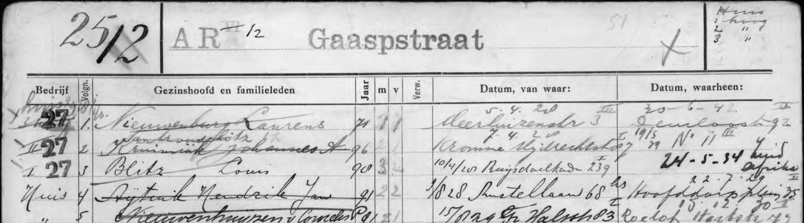
"summary": "The house at Gaaspstraat 12 got a different house number around 1934-1935. Then the street was renumbered. Number 12 became number 25. The family, with Miep Santrouschitz, first lived on 25-III and from August 29, 1940 on 25-Hs.",
"summary_nl": "De woning op Gaaspstraat 12 kreeg omstreeks 1934–'35 een ander huisnummer. Toen werd de straat omgenummerd. Nummer 12 werd nummer 25. De familie, met Miep Santrouschitz, woonde eerst op 25-III en vanaf 29 augustus 1940 op 25-Hs.",
"summary_en": "The house at Gaaspstraat 12 got a different house number around 1934-1935. Then the street was renumbered. Number 12 became number 25. The family, with Miep Santrouschitz, first lived on 25-III and from August 29, 1940 on 25-Hs.",
"same_as": [
"https://archief.amsterdam/beeldbank/detail/8ac3e4f7-7bab-7e92-c414-12e6e26923a6"
],
"street": "Gaaspstraat 25",
"zipcode": "",
"city": "Amsterdam",
"state": "",
"land": "Nederland",
"location_events": [
294
]
}